Field equipment
The group has several plots for rainfall simulation and infiltration experiments, in both vineyards and abandoned bench terraces. Plots under vineyards are located in the western part of the Ebro Depression, upon glacis and fluvial terraces with gentle slopes (4-5º). Vineyards are organized in line, following the slope direction. They are separated from each other by 3 m where soils are completely un-vegetated. Bench terraces are located in the north-western Iberian ranges. Terraced fields were cultivated until 1950´s, then abandoned and re-colonized by shrubs or used for cattle grazing. The group owns a portable rainfall simulator and instruments for soil and soil properties analysis (e.g., 3m hand auger, TDR, penetrometer, …)
foto simulaciones
Munilla experimental catchment
Within the project INDICA, the group has monitored a small catchment (189 ha) in the Cidacos river valley, between 775 and 1175 m a.s.l.. The Munilla experimental catchment is almost completely covered by abandoned bench terraces, re-colonized by Gensita scorpius and Cistus laurifolius. The catchment is equipped with a complete meteorological station, two pluviometers and a pressure sensor in the stream channel to measure continuously the water level. One of the main objectives is to study the spatial distribution of the sediment and water source areas and their contribution to the fluvial network and main stream. This will provide information to understand the hydrological and geomorphological functioning of abandoned bench terraces, including the restitution of the original drainage network.
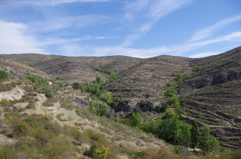
General view of the Munilla experimental catchment.
Laboratories
LSoil and water analysis are usually carried out in the Laboratorio de Análisis Agrarios de La Rioja, from La Rioja regional Government. Sometimes they are sent to the Laboratory of the Instituto Pirenaico de Ecología (CSIC) in Zaragoza. Also, the group has GIS and remote sensing facilities (e.g., sorftware and digital cartography).
|
